February 04, 2010
Storm Of The Century Of The Week Day Watch
We've had two snow storms this week already here in Your Nation's Capital, one on Saturday and one Tuesday night. The forecast folks low-balled the amounts we would get from each of them. While they initially predicted around an inch or so, we wound up getting 4 or 5 inches out of each one.
Well, lo and behold, we've got yet another one coming in tomorrow. This time the O-fficial weather critters seem to be letting their hair down a bit more:
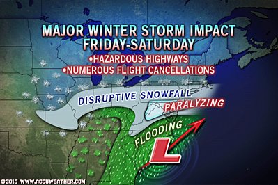
Winter Storm Watch remains in effect from Friday morning
through Saturday evening.* Precipitation type... snow.
* Accumulations... this storm is likely to produce 12 or more
inches of snow in the watch area... with a good chance for
localized amounts over 20 inches.* Timing... snow is expected to begin late morning Friday...
continuing through Saturday evening.
The folks on the radio are also predicting this one will be bigger than the blizzard that hit us back in mid-December.
Further, Jim Cantore was practically swallowing his tongue on TWC last evening while making ominous predictions about another four or five systems lining up way out west that may hit us over the next couple of weeks.
Yup, this is the snowiest winter I can remember here for a long time. Personally, I blame AlGore.
UPDATE: Alright! Now we're really getting into the swing of things:
* Precipitation type... heavy snow.* Accumulations... storm total accumulations of 16 to 24 inches.
* Timing... snow will begin mid-morning Friday... and will continue
through Saturday evening. Conditions will deteriorate rapidly
Friday afternoon... with heaviest snowfall occurring between
sunset Friday to sunrise Saturday. The most hazardous winter
weather conditions will occur Friday night... when the
combination of heavy snow and strong winds will reduce
visibilities to below one-quarter mile... producing near-blizzard
conditions.
Run for your lives!
UPDATE DEUX: Too late!
* Precipitation type... heavy snow.* Accumulations... storm total accumulations of 18 to 24 inches.
* Timing... snow will begin mid-morning Friday... and will continue
through Saturday evening. Conditions will deteriorate rapidly
Friday afternoon... with heaviest snowfall occurring between
sunset Friday to sunrise Saturday. The most hazardous winter
weather conditions will occur Friday night.* Visibilities... the combination of heavy snow and strong winds
will reduce visibilities to below one-quarter mile... producing
near-blizzard conditions at times Friday night and early
Saturday morning.* Temperatures... highs in the lower 30s Friday. Temperatures will
be in the mid to upper 20s Friday night and Saturday.* Winds... becoming northeast 10 to 20 mph Friday with gusts to
30 mph Friday night and Saturday.Precautionary/preparedness actions...
Conditions in this storm are expected to be comparable to those
in the storm of 19 December. Plan for substantial disruptions to
travel Friday afternoon through the weekend.
UPDATE TROIS:
Aaaaaaaah!!!! Why, Snow-Miser? WHHHHHYYYYYYYYYY????????
(Frozen Yips! to Oahu Mike.)
Posted by Robert at February 4, 2010 04:44 PM | TrackBackVery little snow here in Toledo this year. This past summer was cooler than normal, winter a bit warmer than normal. I am fine with that. Anthropomorphic Goebbels Warmening people warn that climate change is going to lead to more extreme weather. I'm experiencing unextreme weather this year.
Was it 1997 when the DC area experienced 3-4 big snowstorms in a row right after Christmas/New Year? I was in Arlington at the time and remember all those storms and various closings.
Posted by: rbj at February 4, 2010 09:14 AMMeanwhile, in the heart of snow country, we *might* get up to four inches overnight Friday - in my suburb, that may not be enough for them to bother plowing the side roads.
Even our weather people were yammering about the storms you are slated to receive.
Posted by: Diane at February 4, 2010 10:30 AMYou are having the winter weather we had in Maine three years ago--one snowstorm after another--whilst we are having a dry-ish winter--one or two big snows followed by weeks of clear--the likes of which we haven't had here for ten or so years. The snow then seems to have been all to the south of us (see above.) Fact is there is no "normal" weather; there is only "average" weather anywhere. And it's cyclical.
Posted by: mothe at February 4, 2010 10:32 AMI guess I need to pick up more steaks to grill, though down here in Richmond we won't get nearly as hammered at the snow.
Posted by: Sarah G. at February 4, 2010 02:15 PMI'm somewhere between the e and s in "disruptive snowfall."
Posted by: GroovyVic at February 4, 2010 06:50 PMI'm supposed to be flying back into Dulles on Sunday evening. I may get there, but may not be able to get from there to home. Best case scenario may me that roads will be clear but my car will be buried in 3 feet of snow out in the Gold Lot.
In the meantime, could you send some of that snow to Vail, Colorado, where we could use it? Thanks.
Posted by: ChrisN at February 4, 2010 07:04 PMI'm above the second "i" in disruptive. I'm too far north for snow?
Posted by: rbj at February 5, 2010 09:29 AM

 Image courtesy of the lovely and talented