April 05, 2005
How Seriously Cool Is This?
I've seen this kind of thing before, but never this user-friendly. It's a new Google/Keyhole Satellite Image Map that lets you zoom all over the place. (The link goes to a satellite image of the White House.)
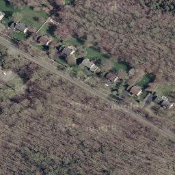
Anyhoo, I played around with it for a few minutes and look what I found: See that house at the upper left with the white fence around the back yard? That's mine. The little white rectangle at the back is my flower garden.
As I say, way cool.
Yips! to Andrew Cory posting over at Dean's World.
UPDATE: Yeah, I know. When the black helicopters start circling around the Butcher's House, you can say "I told you so".
Posted by Robert at April 5, 2005 01:48 PMVery cool, although did anyone notice how Pennsylvania is spelled in the Google link in your post?
Some of the sat photos are rather old - I searched on the courthouse here and none of the PTO complex is in the photo. That construction started over 2 years ago.
Posted by: jen at April 5, 2005 03:23 PMYes, a couple of commenters over at Dean's place caught the typo.
As for the dating, you're right - there's a McMansion across the street from us at the lower right portion of that clearing now. Perhaps it's a security issue.
Posted by: Robert the LB at April 5, 2005 03:44 PMBummer, Galveston's level of detail is much less.
Posted by: owlish at April 5, 2005 03:47 PMWow- that was so much fun. The girls really enjoyed that link, Robert.
Posted by: Rae at April 5, 2005 06:45 PM